Stormy Skies Ahead for Cruise Season as NOAA Warns of Active Year
With just days to go before the official opening of the 2025 Atlantic hurricane season, national weather officials are revealing their predictions about storm activity, something that cruise vacationers will want to keep an eye on.
The Atlantic season runs from June 1 to November 30, 2025, and the National Oceanic and Atmospheric Administration (NOAA) believes there is a 60% chance it will see an above-normal number of storms.
It also predicts a 30% chance of a near-normal season, and just a 10% chance of a below-normal season, NOAA said in a May 22, 2025 announcement.
There are likely to be between 13 and 19 named storms, and of those, between 6 and 10 will become hurricanes, with winds reaching 74 miles per hour or higher. Between 3 and 5 of those hurricanes will strengthen into Category 3, 4, or 5 hurricanes, with winds of at least 111 miles per hour.
If 2024 is any indication, NOAA’s predictions tend to be quite accurate. It predicted, for instance, that there would be between 17 and 25 named storms, and there were 18. It also said that between 4 and 7 storms would become hurricanes, and 5 of them did.
While modern advance-tracking technology enables cruise ships to move out of harm’s way when a tropical storm or hurricane barrels across the Atlantic from the West African coast, there are often still ramifications for cruise guests.
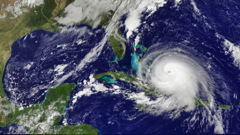
In 2024, Hurricane Debby, which hit the Western Caribbean in August, forced the closure of Port Tampa Bay, leaving Carnival Cruise Line’s Carnival Paradise unable to return to her homeport.
Forced to wait just outside the entrance to Tampa Bay, the ship was late in returning to port, which also impacted embarkation of her next voyage.
When powerful Hurricane Helene hit the Western Caribbean in September 2024, scores of cruise ship itineraries were affected, from the Bahamas to Mexico. Ditto with Hurricane Milton, which swept into the Caribbean and caused itinerary changes and some cancelled cruises from Florida ports.
“NOAA and the National Weather Service are using the most advanced weather models and cutting-edge hurricane tracking systems to provide Americans with real-time storm forecasts and warnings,” said Howard Lutnick, US Commerce Secretary.
NOAA bases its prediction for an above-normal season on a few key factors, including ENSO-neutral conditions, which means there is neither a strong El Niño or La Niña influence on weather patterns this year.
Also, warmer-than-average ocean temperatures are expected to aid in the formation of storms while weak wind shear will help to power hurricanes. Finally, NOAA believes that there will be a higher level of activity in the West African Monsoon, which brings heavy rainfall to the region between June and September.
Tracking Helps Cruise Lines Move Ships Out of Harm’s Way
Cruise lines closely monitor all storms that have the potential to affect weather in the entire Caribbean basin, plus Florida, where the top three busiest cruise ports are located — PortMiami, Port Canaveral, and Port Everglades.
Read Also: How a Hurricane Could Affect Your Cruise
The lines also track any potential movement of a storm into the Western Caribbean as well as northward into the mid-Atlantic and New England states, where cruise ships homeport at destinations such as Baltimore, Cape Liberty (NJ), Boston, and New York.
NOAA’s prediction tools are scheduled for enhancements that will make forecasts even more accurate. The Hurricane Analysis and Forecast System, for example, will be upgraded to provide a 5% improvement rate in tracking and intensity forecasts.
Also, the National Hurricane Center will be able to send out tropical cyclone advisories up to 72 hours prior to the impacts of storm surge or high winds. This will give cruise lines ample notice in advance of possible rough seas, regardless of whether a tropical cyclone advances to hurricane status.
Stormy Skies Ahead for Cruise Season as NOAA Warns of Active Year